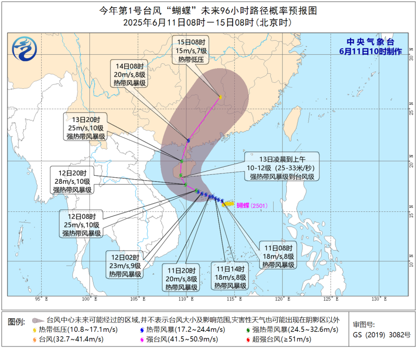
On Wednesday (the 11th), the official weather platform operated by the China Meteorological Administration (CMA) reported that a tropical depression in the South China Sea had strengthened into the year’s first typhoon, named Wutip (Tropical Storm Level). The storm, with an English name of WUTIP and originating from Macao, China (symbolizing an insect), formed around 8 a.m. local time.
According to forecasts, Wutip is expected to approach the southern coast of Hainan Island and western Guangdong by Friday (the 13th). The CMA’s National Meteorological Centre predicts the typhoon will move west-northwest at 10–15 km/h, gradually intensifying before making landfall on the 13th with sustained winds of 10–12 on the Beaufort scale (25–33 m/s). After landfall, it is likely to turn northeastward and weaken.
Typhoon season in the western Pacific typically runs from June to November, often disrupting daily life by damaging crops, closing markets and schools, and damaging infrastructure such as roads and bridges. Last year, Super Typhoon Yagi brought destructive winds to Hainan before moving toward Vietnam, causing severe flooding across the region.
The Hainan provincial meteorological bureau warns that Wutip will bring strong winds and heavy rainfall, with some areas receiving up to 500 mm (20 inches) of rain from Wednesday through Saturday. Vietnam’s weather agency has also issued warnings about rough seas and high waves due to the approaching cyclone.


