
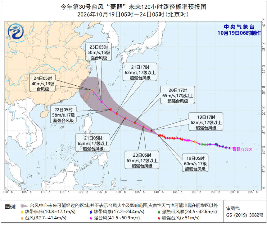
A fresh cold front will move across China between October 19 and 21, triggering steep temperature declines, gales, and heavy rain and snow in certain regions. At the same time, Super Typhoon Champi is tracking northwestward over the western Pacific Ocean. It may edge closer to the seas east of Taiwan Province later this week, though meteorologists cannot yet confirm its final route.
Plunging Temperatures Driven by Cold Air
Broad stretches of central and eastern China will see temperatures dip by 4 to 6 degrees Celsius. Sections of western North China and Northeast China may register temperature falls exceeding 8°C.
Regions north of the Yangtze River will mostly see north winds at Force 4 to 6, and wind gusts can hit Force 7 to 9.
Showers will hit portions of eastern Southwest China, the Jianghuai plain, Jianghan area and western Jiangnan. Some locales will receive moderate or heavy rain, and isolated spots may face downpours.
Western Gansu, Inner Mongolia, northern Hebei, eastern Jilin and northern Xinjiang will also get snow or sleet. Heavy to extreme snow is projected for high-elevation zones in Xinjiang.
China’s National Meteorological Center reissued a blue gale warning at 6 a.m. on October 19.
Between 8 a.m. October 19 and 8 a.m. October 20, Force 5–7 winds with gusts of Force 8–9 are predicted for eastern Xinjiang, most of Inner Mongolia, western and northern Liaoning, western Jilin, southwestern Heilongjiang, the majority of Qinghai, Ningxia, northern Shaanxi, northern Shanxi, northern Hebei and large parts of Tibet.
Sections of the southern Yellow Sea will also have Force 7 winds, accompanied by gusts reaching Force 8 to 9.
Super Typhoon Champi May Draw Near to China This Week
Super Typhoon Champi, the 30th typhoon formed this year, packed peak sustained winds of 60 meters per second (roughly 216 km/h) and a central air pressure of 920 hectopascals as of 5 a.m. October 19. At that moment, it sat about 2,300 kilometers to the east-southeast of Taipei.
Champi travels northwest at a speed of 20–25 km/h and will gradually move toward waters east of Taiwan, with potential further strengthening.
It is still unclear whether the typhoon will strike China’s land. Its subsequent path will partly hinge on how the advancing cold air impacts the western Pacific subtropical high during Wednesday and Thursday.
A stable subtropical high raises the odds that Champi will make landfall in China. If this pressure system weakens or collapses, the typhoon might curve north toward Japan instead.
Forecasts indicate Champi will not impact China’s offshore waters before October 21.
Local people should keep checking official weather bulletins to follow updates on the cold snap, high winds and shifts in the typhoon’s trajectory.